The Bering and Baltic seas were where ice extent increased, driven mainly by cold weather and winds from the north. Elsewhere it decreased or was near average.
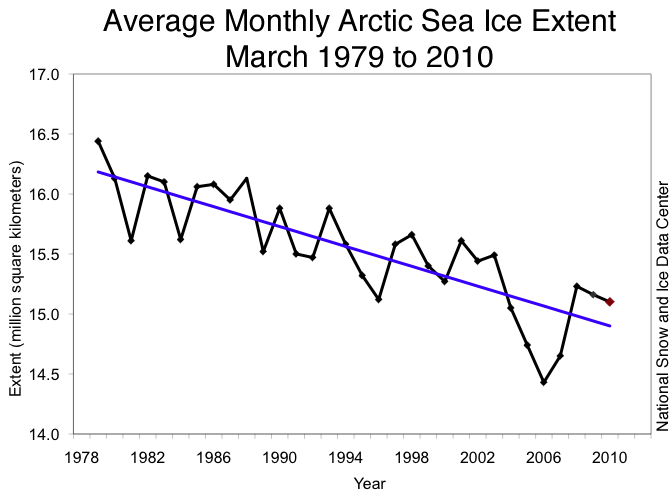
The maximum extent was 15.25 million square kilometers (5.89 million square miles). This was 670,000 square kilometers (260,000 square miles) above the record low maximum extent, which occurred in 2006. Usually there is a decrease in ice during March, but this March the ice extent grew at an average of 13,200 square kilometers (5100 square miles) per day. The linear rate of decline for March over the 1978 to 2010 period is 2.6% per decade as shown in this chart from the National Snow and Ice Data Centre.
The larger amount of multiyear ice could help more ice to survive the summer melt season. However, this replenishment consists primarily of younger, two- to three-year-old multiyear ice; the oldest, and thickest multiyear ice has continued to decline. Although thickness plays an important role in ice melt, summer ice conditions will also depend strongly on weather patterns through the melt season.The report also states that there aren't any satellites taking ice thickness measurements across the whole of the Arctic right now:
At the moment there are no Arctic-wide satellite measurements of ice thickness, because of the end of the NASA Ice, Cloud, and Land Elevation Satellite (ICESat) mission last October. NASA has mounted an airborne sensor campaign called IceBridge to fill this observational gap.
If you go to the NSIDC website, there are some good images showing the change in ice thickness over the past twenty years or so, with the decline in older ice overall, and the slight recovery this past year.
No comments:
Post a Comment